Q-Bot: Multimodal Thermal 3D Scanner
Mechanical, mechatronic, and system-level development
- LiDAR
- Thermal Imaging
- Sensor Fusion
- Precision Motion
- Point Clouds
- Camera Calibration
- BIM
- Patent
TL;DR
A thermal camera tells you where heat is escaping. A 3D scanner tells you what you are looking at. Neither, on its own, tells you which thermal pixel belongs to which physical surface. The Q-Bot scanner solves that by putting laser ranging, several thermal cameras, and RGB cameras on one precision rotating stage with deliberately overlapping fields of view, so all three observations can be tied to the same point in space. A full 360° sweep captures a room's geometry, appearance, and surface temperature in roughly 60 seconds, and every point in the resulting cloud carries an XYZ position, a temperature, and a colour. I worked on the mechanical, mechatronic, and system-level development as part of Q-Bot's engineering team, and I am a named co-inventor on the resulting patent application, WO2020079394A1, "Sensor Apparatus".
This is not a thermal camera on a tripod. The instrument is the sensor geometry.
Why fuse them
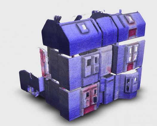
A standalone thermal image flattens a building into a picture: you can see a hot patch but not reliably say which surface, junction, or reveal it belongs to. Anchoring thermal data to scanned geometry removes that ambiguity. In the whole-terrace scan below, the warm signatures sit exactly where they occur, on specific window reveals, door openings, and junctions between elements. That is the difference between "this facade leaks heat" and "these five windows leak heat," and it is what makes the output survey evidence rather than an illustration.
Gallery
The sensor geometry is the invention
Rotating laser scanners were not new. Terrestrial survey scanners from the established instrument makers already did geometry well, so nothing about spinning a rangefinder on a tripod was going to be novel. What the design contributes is the arrangement: a rangefinder, multiple thermal imagers, and conventional cameras on one rotating head, with their fields of view deliberately overlapping each other and the rangefinder's, and their principal axes arranged to intersect, or nearly intersect, the axis of rotation.
Two things follow from that geometry, and both are the reason it is worth designing carefully rather than just bolting sensors to a plate.
Parallax is the enemy of fusion. If the rangefinder sits 200 mm from a thermal camera, a nearby object appears in materially different places to the two sensors, and mapping a thermal pixel onto a 3D point becomes an exercise in correcting for an offset that changes with distance. Pulling the sensors' principal axes onto the rotation axis shrinks that offset, which simplifies registration and improves the accuracy of the fused result. Minimise the physical offset and you avoid having to model your way out of it later.
Overlap buys you calibration. Using several lower-cost thermal imagers rather than one expensive one is a cost decision, but it only works if you can trust the numbers they produce, and cheap thermal sensors disagree with each other and drift over time. Because their fields of view overlap, the same physical surface is measured by more than one camera at once, which gives a basis for cross-calibrating them and correcting drift. The layout that makes multi-camera coverage possible is the same layout that makes it trustworthy.
Angular precision
Every 3D coordinate depends on two things: how far the laser says the surface is, and which direction the head was pointing when it measured. Backlash or positioning error in the stage turns directly into spatial error at the wall, and the geometry is unforgiving. At a 5 m measurement distance, a yaw error of only 0.1° puts the point roughly 8.7 mm from where it belongs, which is the same order as the building features a survey is meant to resolve. That is why the platform used a zero-backlash, high-accuracy rotating stage rather than a housing turning on a convenient bearing. Precision mechanics were a requirement of the data quality, not a luxury.
From point cloud to building data
One scan position always leaves occlusions: furniture hides walls, doorways hide rooms, corners hide everything past them. The instrument was therefore the acquisition layer of a larger system rather than the product itself. Scans from multiple positions register together into a combined dataset, feature extraction identifies building elements such as windows, doors, radiators, and services, and the output becomes floor plans, simplified 3D models, and structured property information, including Revit models and COBie exports for asset and facilities management. Survey data, imagery, and operator input from the field app were held in cloud storage and served to customers and asset managers through a secure web interface.
The point is worth stating plainly: this was a hardware, software, and cloud system, and the scanner's value came from what the data became downstream.
The patent
The architecture is disclosed in WO2020079394A1, "Sensor Apparatus", with a priority date of 15 October 2018, filed as a PCT application in September 2019 and published in April 2020. I am one of six named co-inventors, alongside colleagues from Q-Bot's engineering team, with Q-Bot Ltd as applicant. The disclosure centres on exactly the thing described above: a portable sensor unit combining rangefinding, multiple thermal imagers, and conventional cameras on a controlled rotating platform, with the overlapping fields of view and the sensor placement relative to the rotational axis as the distinguishing features.